Dee Why is a suburb of northern Sydney, in the state of New South Wales, Australia, 18 kilometres north-east of the Sydney central business district. It is the administrative centre of the local government area of Northern Beaches Council and, along with Brookvale, is considered to be the main centre of the Northern Beaches region.
Dee Why Useful Links
- Map of Dee Why
- Dee Why Surf Life Saving Club
- Dee Why Properties for Sale
- Dee Why Restaurants
- Things to Do in Dee Why
Dee Why History
 Name
Name
The reasons for Dee Why’s name remain unclear. The earliest reference to it is a pencil note in surveyor James Meehan’s field book, “Wednesday, 27th Sept, 1815 Dy Beach – Marked a Honey Suckle Tree near the Beach”. What it meant to him is not clear, but various claims have been put forward, including:
– The letters DY were simply a marker that Meehan used to mark many other places on his map.
– The name came from the local Aboriginal language that Meehan used to name many of the locations that he surveyed.
– Lawrence Hargrave, in his unpublished 1910 manuscript Lope de Vega, theorised that the suburb’s name was evidence of the Spanish explorer in pre-settlement Australia, arguing that Meehan misread some local carved initials (since lost): “De V” – for de Vega.
– From 1840 the name was recorded as one word, ‘Deewhy’. The term ‘Dee Why’ was also used to name ‘Dee Why Heights’ or Highlands, known as Narraweena since 1951, and ‘Dee Why West’, the name of which was changed to Cromer in 1969.
Dee Why Post Office opened on 26 April 1915. Dee Why Beach Post Office opened on 1 December 1945 and closed in 1979. Dee Why North Post Office opened on 1 October 1959 and closed in 1993.
Early development
The first land in the area to be listed by the New South Wales government Gazette was 700 acres (280 ha) granted to William Cossar in the early 19th century, James Wheeler purchased 90 acres in 1842, but by the mid-19th century most of the land in what is now Dee Why had been acquired by James Jenkins and other members of the Jenkins family. Elizabeth Jenkins, eldest daughter of James, gave all her land to the Salvation Army upon her death in 1900, in recognition of their support in her old age. The Salvation Army received in total 1,740 acres (700 ha) of land, 200 acres (81 ha) of which were in Dee Why. An industrial farm, as well as hostels for boys, girls and women were established on this land. Access to the beach was limited by the Salvation Army’s land, with a wire netting barrier running along its length.
Warringah Council was formed in 1906, giving Dee Why residents a local government. In 1911 it was decided that the tram line that had expanded in sections from Manly since 1903 was to be extended from Brookvale on to Collaroy Beach via Pittwater Road, and soon after to Narrabeen. By 1920, most of Dee Why had been subdivided. From the end of 1938, the trams, as a result of losses due to low population density and competition with new bus routes that duplicated their services, operated only at peak hours for commuters and on weekends for tourists, and finally ceased operating with the final run on 30 September 1939.
In 1971, work began on a new Dee Why civic centre, inspired by Sulman Prize-winning architects Edwards, Madigan & Torzillo. The building was completed in 1972 and the Council moved there in 1973 from the Shire Hall in Brookvale where meetings had been held since 1912, making Dee Why the seat of Warringah Council.
Dee Why Demographics
According to the 2011 census, there were 19,838 residents in Dee Why. 56.1% of people were born in Australia. The most common other countries of birth were England (5.7%), New Zealand (3.4%), China (3.2%), India (2.8%) and Brazil (2.2%). the most common spoken languages were English, Serbian, Italian and Tongan. Dee Why’s housing is higher density than average for Australia. Of occupied private dwellings in Dee Why, 76.5% were flats, units or apartments with only 19.5% of dwellings being separate houses.
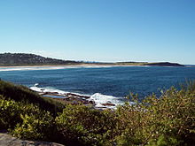
Dee Why Beach
Dee Why Beach runs for about 1.2 km along the eastern border, overlooking the Tasman Sea. To the north are the dunes separating the beach from the Dee Why Lagoon. At its southern end is the Ted Jackson Reserve (renamed from Dee Why Beach Reserve in October 2010), with picnic areas and century old Norfolk Island Pines, similar to the ones in Manly. The reserve is contained by a seawall running for approximately 400m, and was upgraded in 2006, with new pathways, stairs, lookout platforms, an upper promenade and the restoration of the war memorial. There are two playgrounds in the vicinity, located at the southern end of the beach and west of the Dee Why Surf Life Saving Club, near to the lagoon, and several ocean pools located below cliffs to the south. Car parking facilities exist in the streets to the south, as well as a car park next to the Life Saving Club.
Dee Why Translation Services
 Sydney Translation Services provide document translation and typesetting services for business and residents in Dee Why. Our Dee Why translation service includes certified translation by NAATI translators, as well as professional translation and typeset for marketing and training material. Our translation services are diversified across different fields, we provide medical, legal, financial, engineering, public policy, scientific and book translations.
Find translators – Capalaba West, Carina, Carina Heights, Carindale, Chandler